|
|
Termes, cultural references in Termenès |
|
[Historical
account] [Map
of the castle] [The castle] [Village] [Church of our Lady] [Saint-Andrew
chapel] [Water mill] [Passes] [Pruned Box-trees] [Association] [Bibliography] [Links]
[Copyright] [Summary]
TERMES (Tèrme)
City
of the Cathar Country
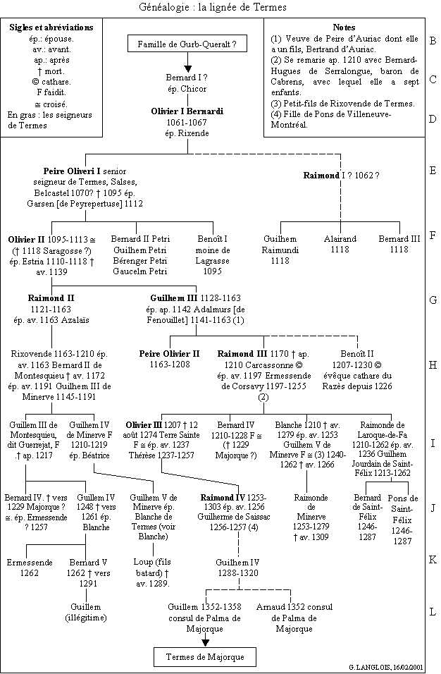
The seigniorial family of Termes The seigniorial family of Termes first appears
in the records in 1061. It ruled the Termenès which, in the early 11th Century,
was a large feudal estate in the southern part of the county of Carcassonne.
South of its borders was the count of Cerdagne later ruled by king of
Catalunya. Throughout the 12th Century, the family was in periodic conflict
with the neighbouring abbey of Lagrasse, mainly over the possession of the Palairac
silver mines.
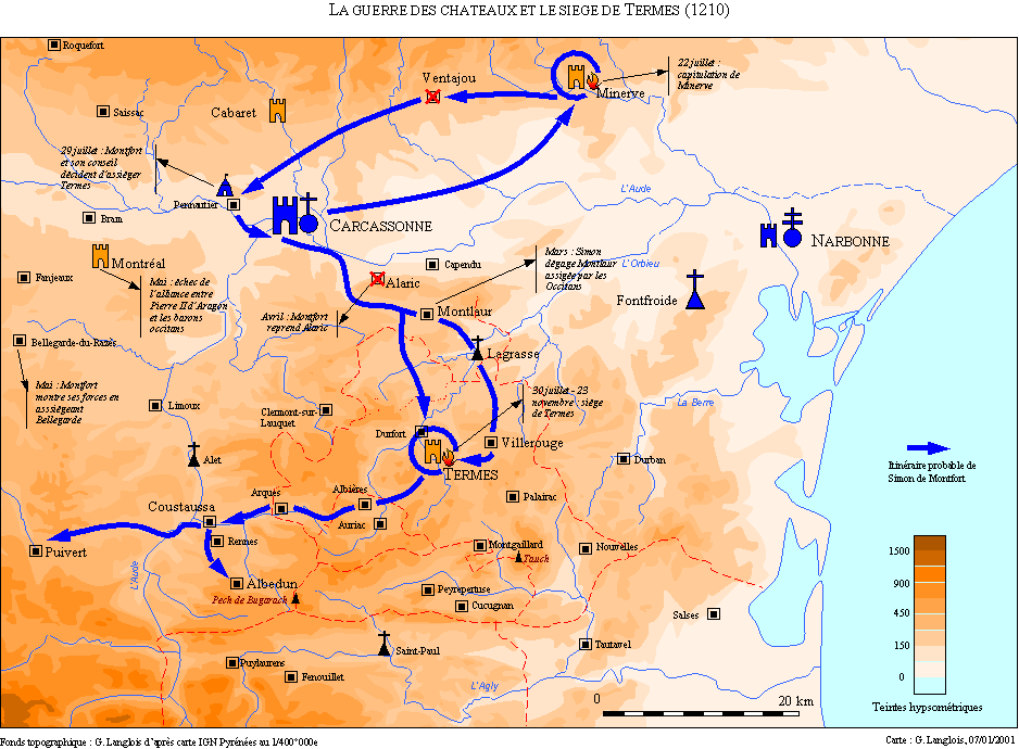
During
the Albigensiam Crusade, Simon de Montfort, earl of Leicester,
captured Carcassonne and then invested the three main fortified towns of the
county. He failed to subdue Lastours but after the fall of Minerve he turned
his attention to Termes. By 1210, the date of the siege, the layout of the site
was as follows : on the crest of the hill stood the castle, the home of
the seigniorial family, consisting of an outer wall which incorporated various
buildings including a chapel and with a rectangular keep at its centre. A
second surrounding wall sheltered the knight's houses. The castral village lay
on the southern slope protected by another wall which joined the castle walls.
In the river valley to the east was another settlement (the present-day
village) with a parish church built in 1163. On the northern edge of the hill
lay a small fort, the Termenet, which controlled that approach.
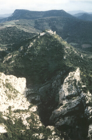
The site from the north. In the foreground
the passes of Termenet or la Frau,
in the middle distance, the rock who supported the tower of Termenet,
in the background the castle.
The
Termes family appears to have adopted Catharism by the time of the siege.
Raymond, seignior of Termes, had been accused of heresy and had not heard mass
in the castle chapel for thirty years. The "parfait" (one of the
Cathar elite) Benoît de Termes, probably Raymond's brother, was one of the
group of heretics who debated with Saint Dominic at the Montréal colloquium in
1207 ; he was elected cathar bishop of Razès in 1226.
The
siege started at the beginning of august with a catapult duel between the
attackers and the besieged. De Montfort, failing in his assault on the southern
flank, switched his attack to the northern approach, investing Le Termenet and
then bombarding the keep. Finally the siege was ended by water problems. The
defenders contracted dysentery from stagnant water tanks and deserted the
castle during the night of 22/23 November. Raymond de Termes stayed behind and
was arrested. He eventually died in prison at Carcassonne. The fortress was
confiscated and became the property of the crown in 1228.
Sir Oliver de Termes, son of the defeated seignior,
continued to resist the royal forces, along with the count of Toulouse and the
viscount of Carcassonne, until 1240 when he entered the service of Louis IX
(Saint Louis) in Languedoc and subsequently in the Holy Land where he died on
the 12th August 1275 leading the army of the Kingdom of Jerusalem. A friend of
Saint Louis, king James of Aragon and pope Clement IV, he was regarded by his
contemporaries as one of the most courageous soldiers of his time.
Integrated
into the chain of fortresses guarding the frontier with Aragon, then Spain, the
castle of Termes was rebuilt in the middle of the 13th Century and manned by a
royal garrison. In the 17th Century, as the border recede, the fortress lost
its purpose and was destroyed by royal command. Throughout the years 1653
and 1654 a master mason from Limoux blew up the walls with gunpowder. After
that the site sank into oblivion. It was not until the 20th Century that
preservation measures were taken. Classified as a "site" in 1942, and
as an historic monument in 1989, the ruins became property of the commune and
were opened to the public.
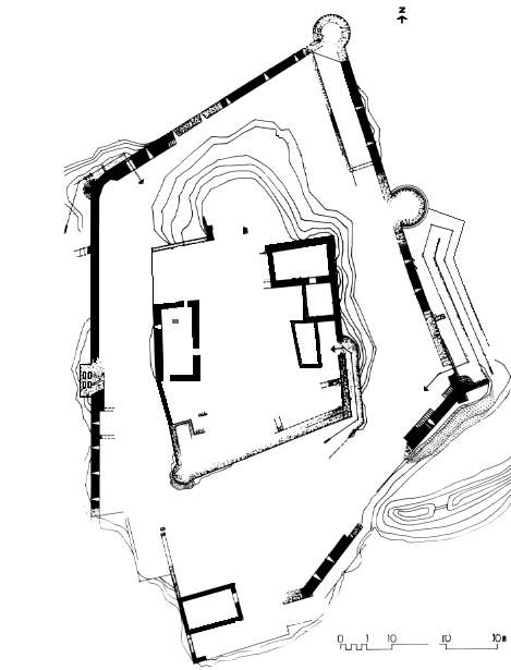
The
castle, built on a platform surrounded on three sides by a deep ravine, was
only accessible from the south. Below the summit it is possible to wake out the
ruined wall of the medieval village later used for terracing. Above this is the
castle wall ; the main entrance (13th Century) in the south-east corner is
by means of a ramp leading to a ruined gateway. This entrance was guarded by a
watch-turret and a bossage tower which could fire on the ramp. The pre-13th
Century entrance was probably in the south-east corner. A postern (sally point)
(10) protected by a watch-turret built on the buttresses remains on the
north-west side.
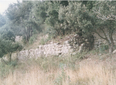
The ruined wall of the medieval
village,
vestiges of a rectangular defence on the west side, later used for terracing.
This
postern gives access to the Termenet site : the only remains of this small
fort, described by a chronicler of the Albigensian Crusade, consist of a
fragment of masonry hidden in a crevice and some dug-out rocks. From this
point, there are superb views of the castle, the gorges of Termenet and the La
Buade mill.
Amongst
the ruins of the second wall are vestiges of an access ramp and traces of a
water-tank and a washbasin. On the west side is the chapel with a collapsed
vault ; it is lit by two Romanesque windows, one of which is cruciform. At
the summit are enormous blocks of masonry, remains of the keep destroyed in
1654.
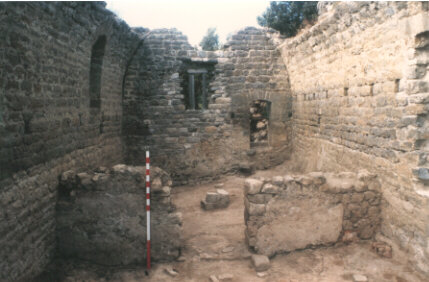
In 1994 the archaeological
excavations confirmed that this room was the chapel : behind a later wall who
divided the room in two parts, was found a pillar who supported the
altar-stone.
All
together few of the remains pre-date the Crusade ; part of the southern
face of the first wall, the second wall and some of the buildings it protected.
The remainder is the work of a royal engineers in the second half of the 13th
Century and the beginning of the 14th.
Termes,
at the foot of the castle hill on a south facing slope, is in a bend of the
river Sou. In 1163 this was an outlying area where the seigniors planned to
build a parish church. The main village was inside the wall, still visible
hallway up the castle slope. This original village was destroyed in the siege
of 1210 and the inhabitants re-built their homes in the valley. In the 13th
Century Termes was the centre of the judicial area of Termenès and of a
religious area under the supervision of an arch-priest. The village
qualified for the title "ville" until the 17th Century when its importance
was reduced by the transfer of the judicial seat to Félines-Termenès.
At
the top of the village old threshing floors are still visible in the form of a
terrace. These primitive facilities are evidence of the traditional
agricultural methods practised until the beginning of the 20th C.
THE CHURCH OF OUR LADY OF
NATIVITY
The
church dates from 1163 according to the act which divide the castle between the
brothers Raymond and Guillaume de Termes. Since then there have been no significant
alterations apart from the raising of the north wall in 1890 in order to reduce
the slope of the roof (on this side some of the original flat stones underneath
the canalisation tiles can still be seen) ; the removal of the door from
the south to west side (1880) ; the transformation of the windows (19th
Century) and the reconstruction of the bell tower at an unknown date (part of
the primitive wall belfry steel be seen in the present bell tower).
The
building has a single rectangular nave with a flat chevet. The pointed
barrel-vaulted sanctuary has three bays. Pilasters support arches band, a
moulded cornice runs along the walls and turns back in impost into the
pilasters. A chamfered cornice rests on quarter-round corbels on the north and south
walls. The doorway is built in the form of a round arch. The bell-tower holds a
bell dating from 1541 dedicated to the Virgin Mary. Inside the sanctuary there
is a holy water basin resting on corved stones bearing the coat of arms of
Pierre de Montbrun, archbishop of Narbonne (1272-1286). Behind the altar there
is a 17th Century painting of the Virgin and Child between Saint-Cecile and
Saint-Catherine.
To
the south-east of the village, in valley of the Sou stands a small chapel named
after Saint Andrew. The original medieval building was surrounded by a burial
ground in 1673. The present edifice is of more recent date and was restored in
1890. It contained a wooden statue of Saint Andrew. In periods of drought the
people of Termes would came in procession and plunge the statue into the river.
Rain was expected to follow this ceremony which was undoubtedly of
pre-Christian origin.
There
are two mills in Termes. One is now a village house, the other - the La Buade
mill- is situated 2.6 kms downstream on the left bank of the Sou. The entire
mechanism is in working order from the water channel to the millstones turned
by an horizontal wheel. (Private property).
THE TERMENET AND COYNEPONT PASSES
Between
the La Buade mill and the village, the road, constructed in 1903, passes
through two tunnels in the gorge of Termenet cut by the Sou. The steep
walls of the gorge consist of rocks of the middle and lower Devonian periods.
In the centre a beautiful vein of red marble runs the height of the cliffs. The
gorge is in a protected area.
South
of the village, upstream of the Saint Andrew chapel and still on the Sou, there
is another protected natural site -the gorge of Coynepont. This also cuts
through rock of the lower Devonian period. The middle section forms a bowl and
in part of the river bed a jumble of travertine rocks indicates a collapsed
natural bridge. (Coynepont means "the cave bridge" in Occitan).
As
in other villages of the western Corbières, the D 40 road into Termes is lined
with box trees pruned into strange shaped. The Works Department maintains the
local tradition and the trees are regularly pruned into spheres, cubes and
other shapes. This practice seems to go back to the year 1900 when the road was
built.
THE TERMES EN TERMENÈS ASSOCIATION
This association has been working for the protection and improvement of the site since 1989. It organises excavations each summer. Address : Mairie, 11330 Termes. Phone number +33 (0) 468 70 03 84.
ASTRUC (Abbé J.L.), Termes en Termenès, Grenoble, 1939.
BAYROU (L.), "Essai sur les techniques de construction des forteresses royales des Corbières, XIIIe et XIVe siècles", Études Roussillonnaises, VIII, 1988, pp. 7-170.
BAYROU (L.), Le château de Termes, Centre d’Archéologie Médiévale du Languedoc / C.D.P.C.A., 1989.
LANGLOIS (G.), "La formation de la seigneurie de Termes", Heresis, n° 17, 1991, pp. 51-72 et n° 18, 1992, p. 71.
LANGLOIS (G.), "Le siège du château de Termes par Simon de Montfort en 1210, problèmes topographiques et historiques", Heresis, n° 22, 1994, pp. 101-134 et n° 24, 1995, pp. 87-89.
LANGLOIS (G.), "Étymologie et orthographe de Termes (Aude), et des noms dérivés", Bulletin de la Société d'études Scientifiques de l'Aude, t. LXXXXIII, 1993, pp. 167-169.
LANGLOIS (G.), "Olivier de Termes et son entourage, de la croisade albigeoise aux croisades en Terre Sainte", Les voies de l'hérésie : le groupe aristocratique en Languedoc (XIe-XIIIe siècles). Actes du 8e colloque du Centre d'Études Cathares / René Nelli, Couiza, 28 août-1er septembre 1995. Carcassonne : Centre d’études cathares, 2001. (Collection Heresis, n° 8), vol. 2, Avant et après la croisade: seigneurs et seigneuries, pp. 207-258.
LANGLOIS (G.), Olivier de Termes, le cathare et le croisé, Toulouse : Éditions Privat, 2001, 288 p.
PEAL (A.), "Olivier de
Termes and the Occitan Nobility in the Thirteenth Century", Reading
Medieval Studies, XII, 1986, pp. 109-129.
|
|
File Sir Oliver de Termes. Find on this site some extracts of the book "Oliver de Termes, the Cathare and the Crusader" (abstract, summary, maps of the crusades, genealogy of the family of Termes, the first chapter etc.), a forum of discussion on the siege of Termes and Oliver de Termes. You can order the book also there. "Travel on
Occitania" The Cathar country Ce site propose notamment plusieurs
photographies du château de Termes un forum consacré au siège de Termes et
des informations pratiques pour la visite. |
Written by Gauthier LANGLOIS for the Association Termes-en-Termenès, with the
help of the Département de l'Aude, the municipality of Termes, and the Centre
of Medieval Archaeology of Languedoc. Translated by Géraldine LABADIE, Peter
and Sybil SCROGGS, Jun 1994. Map by Lucien Bayrou.
© Copyright Conseil Général de l’Aude and Gauthier
Langlois for the text, Lucien Bayrou for the map. All rights reserved.
|
|
[Summary] |
Page made by Gauthier LANGLOIS Extract
from the site Paratge at the address : |
